
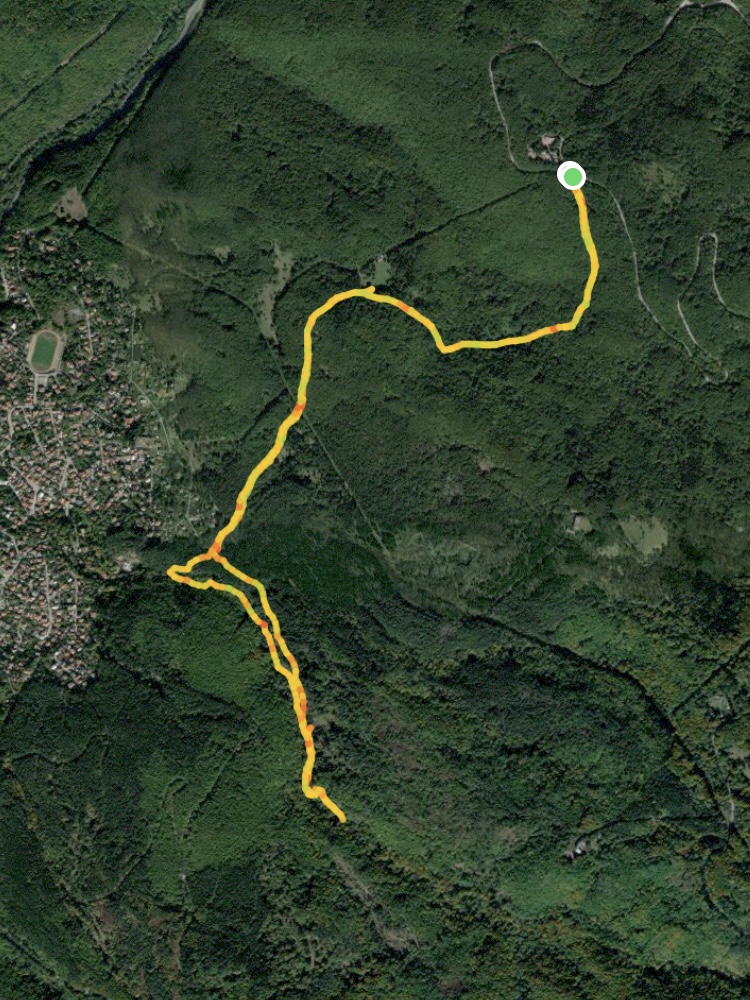
Starting coordinates: 42.63811, 23.21968
Distance: 7.6 km
Elevation Gain: 330 m
Time: 3 hours
Difficulty: Moderate
Transport: by car, or by bus no. 63 to Tihiya Kat
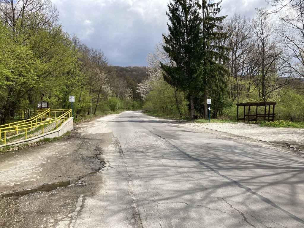
The road from Boyana goes past a motel, Tihiya Kat, on the left and a bus stop on the right. This is the start of the walk. 
The path descends straight into forest. 
It winds between the trees. 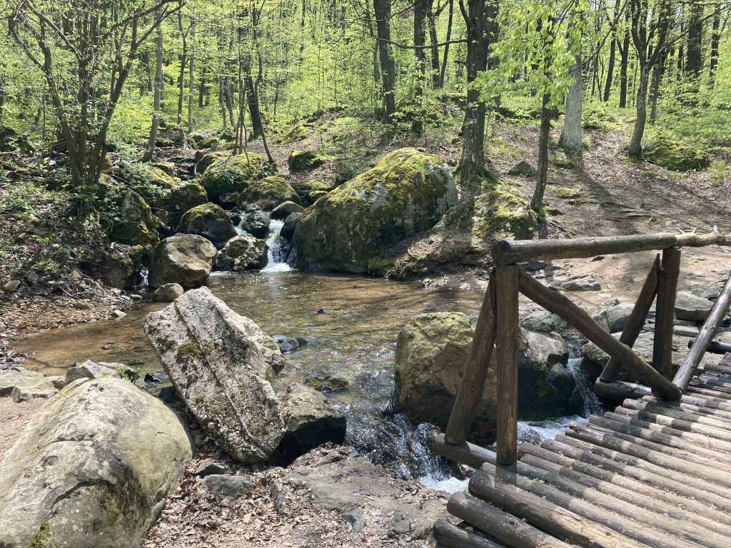
After five minutes, you reach a bridge across a small stream. 
There is then a hut on your right. 
Horses use this trail as well! 
A field on your right contains farm buildings. 
When the path begins to veer right towards the village, you continue straight. 
You soon come to a clearing with paths going up and down the mountain. 
You take the second path on the left (the “low-altitude circular trail”), which is crossed by small streams. 
Vladaya River can now be heard and seen on your right. 
There is a grassy area with high rocks on your left. 
You continue uphill. 
At the top of the rocks is another grassy area which people use to light fires. 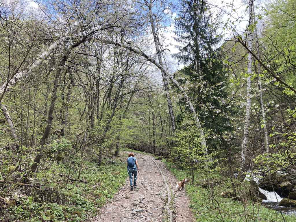
The path now follows the course of the river. 
Vladaya River before it goes under the bridge. 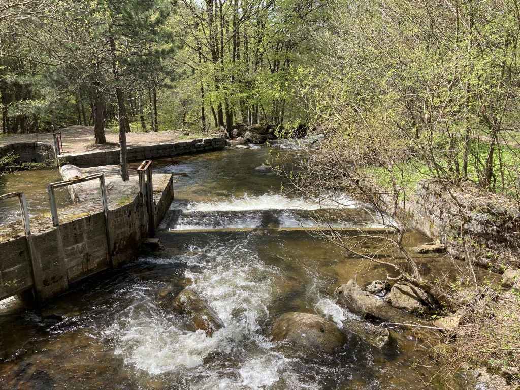
The shallow area and sluice on the lower side of the bridge. 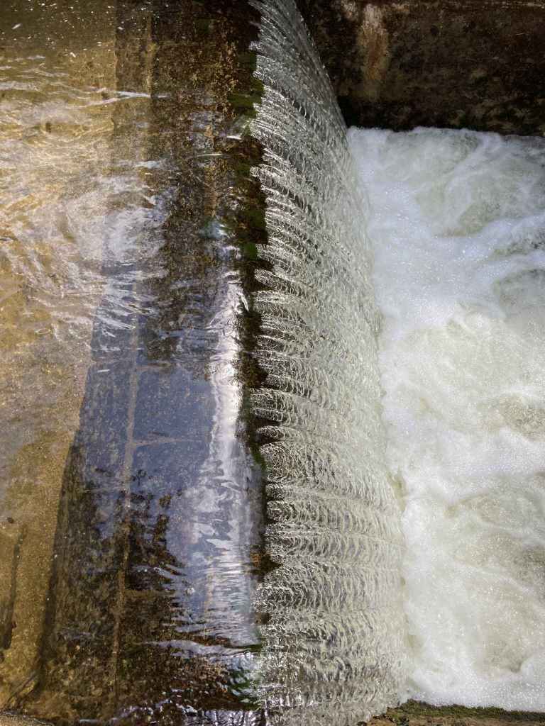
The beauty of water. 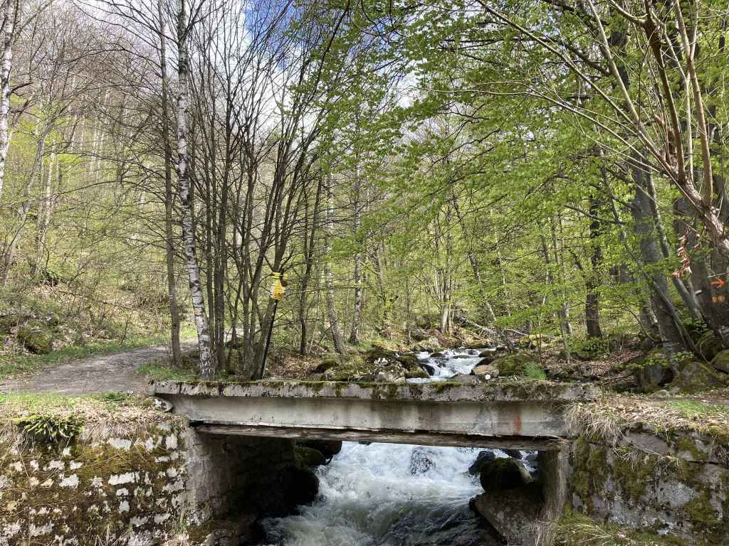
The bridge over Vladaya River, as far as this walk goes. 
Coming back down, you take the path on your left that continues alongside the river and soon reach a bridge. 
Having crossed back over, you leave the river behind and return to the clearing. The route back to Tihiya Kat is now the same.
This is one of the loveliest walks on Vitosha and it has the advantage of being a good walk to do even when the weather is bad because it’s lower down the mountain. You take the car or bus on the road that climbs the mountain from Boyana Village and stop at a motel-restaurant called Tihiya Kat. The motel is on your left. The walk starts at the bus stop on your right.
A path descends straight into forest and takes you to the next village around the mountain, Vladaya. After about five minutes, you reach a bridge over a stream. A few minutes later, there is a hut on your right where people light fires. After another ten minutes, you come to some farm buildings in a field on the right where there are sometimes horses. In fact, this path is part of a “low-altitude circular trail” that goes all the way around the mountain and is shared by walkers, cyclists and horse riders. In another ten minutes, there is a path on the left before a pylon, followed by another path on the left after the pylon. There are some tables here where you can rest. Continue on the shared trail, and soon the village of Vladaya will become visible through the trees on your right. After five minutes, a path joins from the left. The path you are on begins to veer to the right to enter the village, but you want to go straight ahead (signposted for Marchaevo and Kladnitsa), not into the village.
In a couple of minutes, you come to a clearing. A path on the left leads up to Planinets, a mountain hut which is the start of another walk. A path on the right leads down to the village. You want the second path on the left (signposted for Zlatni Mostove, Kumata and Cherni Vrah). This second path is, in fact, a continuation of the low-altitude circular trail. There is a small path in front of you which leads down to Vladaya River. You will come back on this path.
So take the second path on the left. You can now hear Vladaya River on your right and later you will be able to glimpse it through the trees. The path is crossed by several small streams on their way to the river. It then starts to climb. After fifteen minutes, you reach an abandoned house on the right. Immediately on the left is a plaque in memory of someone who died. This is followed by some high rocks on the left with a grassy area where people light fires. The route continues uphill, but note the path behind you, on your right. This is the path you will take on coming back down the mountain.
Continue uphill. You pass the top of the rocks on your left, but carry straight on. You are now following the course of the river. At one point, the path veers away from the river to the left, but it soon curls back again, and in a few more minutes you reach a bridge over the river. The path continues uphill in the direction of Zlatni Mostove (the start of another walk), or you can go over the bridge in the direction of the villages of Marchaevo, Rudartsi and Kladnitsa.
But we will pause at this beautiful spot in order to take a rest and admire the river. The water tumbles under the bridge. There is then a shallow area, with a sluice on the far side. The light on the water makes for a very attractive sight. In fact, this is one of my favourite spots on the mountain.
Having taken your fill, you now retrace your steps back down the mountain, unless you have the whole day in front of you and fancy continuing to Zlatni Mostove or Marchaevo. When after about five minutes you reach the rocks further down, remember to take the path on your left that follows the course of the river. You will divert a little from the route, but you will rejoin it later on. The views of the river are wonderful, especially in winter, when the water level is high. After five minutes, you reach a bridge across the river. Cross to the other side and continue downhill past a small bench and shelter until you reach a second bridge that takes you back to the other side of the river. If you continue downhill on the same side of the river, you will come to the village of Vladaya.
Cross this second bridge and take the path on your left that climbs uphill. After five minutes, another path joins from the right. You then come to the same clearing you were in earlier. Now the route back to Tihiya Kat is the same. You simply keep going straight on the same level (going left will take you down to the village, right further up the mountain) and in about forty minutes you should be back where you started.
This is a wonderful walk, one of my favourite walks on Vitosha. But a word of caution. I have a small dog and I have often come across big dogs in the vicinity of Vladaya or next to the river. There are also horses from time to time. So you might want to keep an eye on your little friend if you have one.

Pingback: Dendrarium – Zlatni Mostove – Planinets – Dendrarium – Stones Of Ithaca
Pingback: Ofeliite – Zvezditsa – Konyarnika – Kumata – Ofeliite – Stones Of Ithaca