
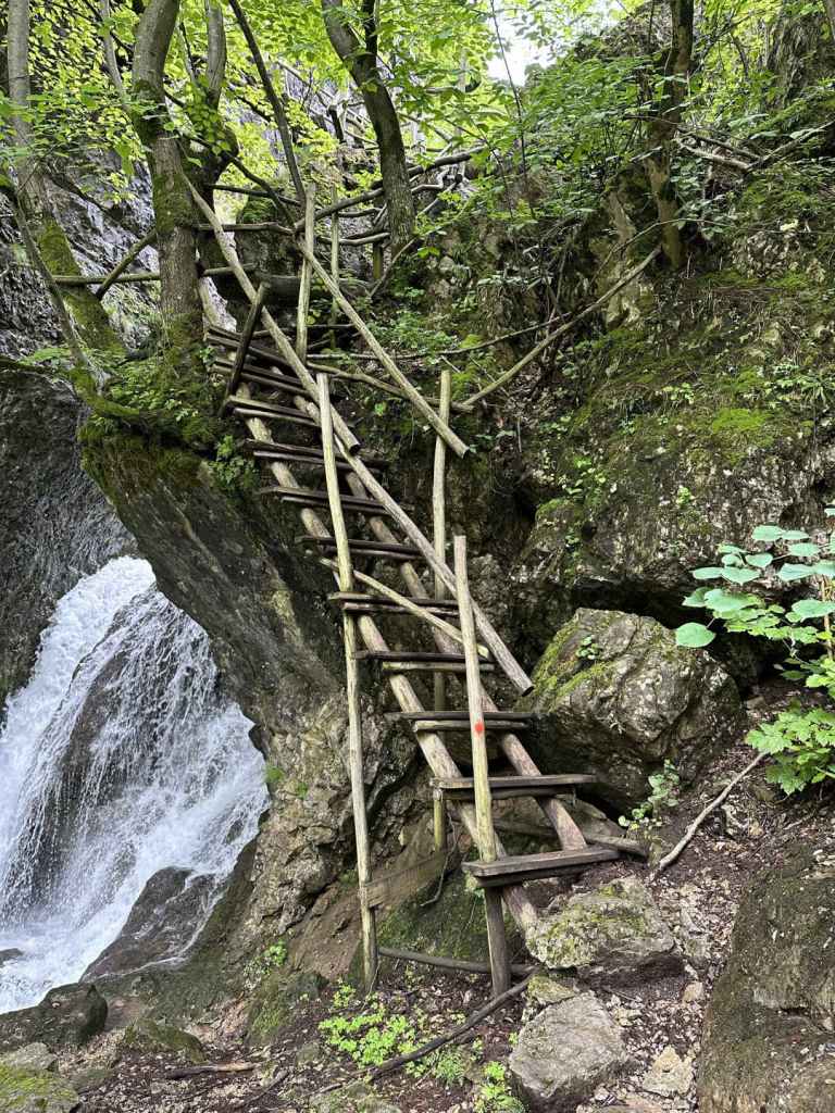
This is an astonishing walk, but it is not for the faint-hearted! To get to the bottom of the waterfall, known as ‘Borov Kamak’ (‘Pine Stone’), it is necessary to climb fourteen ladders, some of which are quite steep, and to cross from side to side of the river Varteshnitsa. We were with a small dog and had to carry him up and down the ladders. Also, in reviews online, a lot of people express their disappointment at the waterfall having no water. We went in the second half of June after heavy rains, and I can say that this was not the case! The waterfall was working at full capacity, and a couple of times, where there was no bridge, it was necessary to wade across the river.
That said, this is one of the most beautiful places I have been to in Bulgaria, and the waterfall is memorable. You get what you put in, I suppose. To reach the old mining village of Zgorigrad, you must first travel to Vratsa. Coming from Mezdra on the E79, you enter the town of Vratsa and keep going straight, following the signs for Ledenika Cave. After three kilometres, you pass the turning on the left for Vratsa Waterfall (directly after the hospital). After another kilometre, ignore the turning right that goes to the centre and follow the sign for Ledenika. In 300 metres, take the turning on the left to Ledenika and Zgorigrad. You leave Vratsa and go through the dramatic Vratsa Pass. After 2.2 kilometres, there is a sign for Ledenika at a distance of thirteen kilometres on the right, but you continue straight and enter Zgorigrad village. Keep going straight, pass through the centre (with the river Varteshnitsa on your right) and, as the road begins to loop, 2.2 kilometres after the centre of Zgorigrad, you come to the start of the ecopath that leads to the waterfall. Park your car on the grassy verge. The river is now on your left.
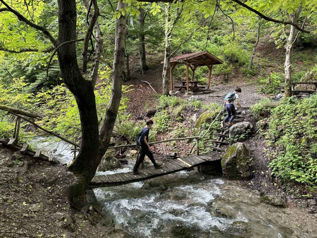
The walk to the waterfall takes about two hours. If you factor in another hour to visit the top of the waterfall, you will need to allow five hours to go and come back. The ecopath climbs the grassy verge and quickly enters forest. On your left is an old tailings pond, used to store waste material from the extraction of metal ore. This tailings pond caused a terrible flood (almost half a million cubic metres) in 1966, with significant loss of life in the nearby village. There is a short film about the disaster by Robart Nikolchev on YouTube. In about twenty minutes, you cross the first of several bridges taking you from side to side of the river. After the third bridge, we were tempted to go straight, but you must go right, uphill, following the course of the river. If you find yourself moving away from the river at any point, then you have gone wrong. Keep an eye on the red markers.
After the fourth bridge, the ladders start in earnest. There are eight ladders in the space of half an hour. After the fifth bridge, we again went slightly wrong and started moving away from the river. Follow the red markers and stay close to the river. Another three ladders, and then comes the fun part. You are required to cross to the lefthand side of the river, but there is no bridge, presumably because there isn’t normally so much water and it’s possible to hop from rock to rock. In our case, the river was roaring down, and this wasn’t possible! We tried taking off our shoes and socks, but the water was so cold we didn’t get very far! In the end, we just waded across. I carried our dog.
Another fifteen minutes, and you come to the bottom of the waterfall, which is 63 metres high. It’s a wonderful location. If you want to visit the top of the waterfall, you need again to cross the river without the help of a bridge. We again got soaked! But it was worth it. There is a picnic table under the eaves of the rocks on the righthand side of the river. You can stop here for lunch and admire the waterfall. We certainly did.
If you decide to continue the top, you must follow the path in front of you, which soon goes left. You must climb another four ladders to reach the top, but the view is amazing and the sensation of watching the river tumble over the edge is exhilarating. There is a place to stand, with a railing, but please be careful. The river before it cascades over the edge is much calmer. You can continue upstream. Having crossed a bridge, in about twenty minutes you will reach a mountain shelter and an open meadow. This is as far as we got.
Beware that descending the ladders is perhaps more difficult than going up (especially when you are responsible for a small creature!). We had heard that the walk to Vratsa Waterfall is quite steep, but found this walk to be more difficult, albeit more beautiful. ‘Borov Kamak’ easily ranks in my top five, along with waterfalls like Hristo Danovo and Polska Skakavitsa.


Pingback: Vratsa – Stones Of Ithaca